What Is LiDAR?
LiDAR, short for Light Detection and Ranging, is a remote sensing technology that uses high-powered lasers to measure distances. It works by emitting light pulses and analyzing the time it takes for the reflected signal to return. This data allows for precise distance calculations and the creation of detailed 3D models.
LiDAR instruments shoot laser beams at objects, then measure the speed and intensity of the returning signals. By processing this information, they can determine exact distances between points, which is essential for creating accurate spatial representations. These models are widely used in various fields, from mapping to autonomous vehicles.
 Flyability's Elios 3's LiDAR sensor glows green as it flies through a water treatment plant
LiDAR has a wide range of applications across industries, including airborne, terrestrial, mobile, and underwater operations. Its ability to be mounted on drones makes it especially valuable in environments where human access is risky or impossible.
Understanding LiDAR Technology
LiDAR stands for Light Detection and Ranging. It is a method of collecting data using lasers and light to measure and map targets from a distance. This technique enables the creation of highly detailed 3D models, making it a powerful tool in many fields.
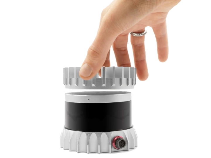
An Ouster OSO-32 LiDAR sensor
The origins of LiDAR trace back to the early 1960s when lasers were first developed. Initially, the term was just a combination of "light" and "radar." Over time, it evolved into a sophisticated technology used for mapping, environmental monitoring, and more.
In the 1980s, with the introduction of GPS, LiDAR became an essential tool for large-scale geospatial data collection. However, early systems were bulky, expensive, and limited in accuracy. Today, LiDAR has become more compact, affordable, and accessible, even appearing in consumer devices like modern iPhones.

LiDAR sensors along with visual sensors on a smartphone
From its humble beginnings, LiDAR has advanced significantly. But how exactly does it work? Let’s take a closer look.
How Does LiDAR Work?
Whether mounted on a drone, plane, or handheld device, LiDAR systems operate by emitting precise laser pulses and measuring the time it takes for them to reflect back. This process enables accurate distance measurements and detailed 3D modeling.
 An infrared photo of a LiDAR sensor | Credit: Ouster
Similar to radar and sonar, LiDAR uses light instead of radio or sound waves. By tracking the direction of the emitted light and the position of the scanner, LiDAR can accurately calculate the 3D positions of objects. This makes it ideal for a variety of applications, from autonomous driving to environmental monitoring.
Every LiDAR system consists of three main components:
1. The Laser
The laser emits pulses of light toward the target. These pulses vary in color and intensity depending on the type of data being collected. When the light hits an object, it reflects back to the system for measurement.
2. The Scanner
The scanner, also known as the receiver, captures the reflected light. Different types of lenses and optics are used depending on the application. Devices like beam splitters or mirrors help collect the return signals efficiently.
3. Global Positioning System (GPS)
To ensure accurate measurements, the LiDAR system must know its exact location. Most systems integrate GPS technology to track their position and orientation in real-time.
Other components, such as batteries, imaging systems, and data collectors, may vary based on the specific use case of the LiDAR instrument.
LiDAR Formula
The fundamental principle behind LiDAR can be expressed mathematically as:
d = c * t / 2
Where:
- d is the distance
- c is the speed of light
- t is the time of flight
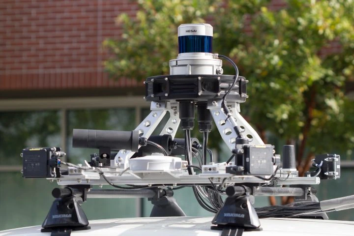
 An Ouster LiDAR sensor attached to a car
Benefits of LiDAR
LiDAR offers numerous advantages over other 3D modeling technologies like photogrammetry. One of its key strengths is its high level of accuracy. Some systems can detect objects as small as individual molecules or as vast as clouds.
Unlike photogrammetry, which requires hundreds of images, LiDAR collects data more efficiently and with greater precision. Additionally, LiDAR can function in low-light conditions, making it ideal for environments like mines or dark skies where traditional cameras struggle.
This reliability is especially important in safety-critical applications, such as emergency response or disaster management. The ability to gather accurate data regardless of environmental conditions can make a significant difference in saving lives and protecting communities.
Other benefits include:
- The ability to automate large portions of data collection
- Flexibility in data source diversity
- Reducing costs as technology advances
 A LiDAR sensor mounted to a self-driving car
Types of LiDAR
LiDAR systems can be categorized in several ways, including the type of laser used, the orientation of the system, and the platform it operates on.
Laser Type
One major distinction is the type of laser used. Topographic LiDAR uses near-infrared lasers to map land features, while bathymetric LiDAR uses green light to measure underwater terrain.
Orientation
LiDAR systems can be oriented in different directions—nadir (downward), zenith (upward), or lateral (sideways). Each orientation serves specific applications, such as atmospheric studies or autonomous vehicle navigation.
Platform
LiDAR can be deployed on various platforms, including drones, airplanes, satellites, and ground-based systems. The choice of platform affects the range, resolution, and coverage area of the data collected.
LiDAR Uses and Applications
LiDAR is used across a wide range of industries. Here are 12 common applications:
1. Accident Scenes
LiDAR quickly captures detailed data at accident sites, helping emergency responders focus on saving lives rather than assessing the scene. This data can also serve as evidence in legal cases.
2. Agriculture
LiDAR helps farmers monitor crop yields, track water levels, and manage livestock. It can even detect insects, providing valuable insights for sustainable farming practices.
3. Atmosphere
Aerial LiDAR is used for pollution modeling, weather analysis, and gas detection, offering critical data for environmental research and climate studies.
4. Archeology
LiDAR has been instrumental in uncovering ancient structures hidden beneath dense vegetation. For example, it revealed a vast road system in Central America, changing our understanding of ancient civilizations.
5. Conservation
Conservationists use LiDAR to monitor forests, wetlands, and coastal areas. It helps predict natural disasters and manage resources more effectively.
6. Inspections
Drones equipped with LiDAR can access dangerous or hard-to-reach areas, improving efficiency in infrastructure and construction inspections.
7. Insurance
Insurance companies use LiDAR to assess damage quickly and accurately, reducing claim processing times and improving customer satisfaction.
8. Forestry
LiDAR provides detailed tree height and density data, aiding in forest management and conservation efforts. It is far more efficient than traditional surveying methods.
9. Law Enforcement
Policing agencies use LiDAR for speed detection and surveillance. It also supports military operations by providing real-time situational awareness.
10. Mining
LiDAR assists in assessing mine safety, measuring ore volumes, and identifying geological faults, enhancing operational efficiency and safety.
11. Transportation
LiDAR plays a role in planning transportation infrastructure, optimizing routes, and managing traffic flow, contributing to smarter cities and better mobility.
12. Self-Driving Cars
Autonomous vehicles rely on LiDAR for obstacle detection, navigation, and parking assistance, making them safer and more reliable on the road.
Mobility Scooter,Mobility Scooter For Elderly,Electric Mibility Scooter,Disabled Mobility Scooters
YUMBOMOBILITY LTD , https://www.yumbomobility.com